A Proof of Concept
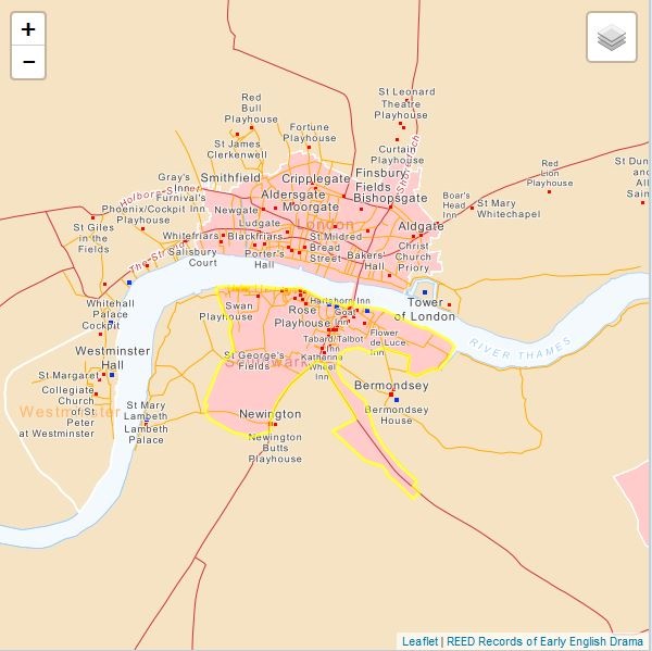
The Rose Playhouse Timeline Demo is a web page designed as a proof of concept for a map-based timeline interface linking map features to records in the Rose Playhouse Prototype edition published on REED Online (2020). The Rose Playhouse Prototype is an integrated digital edition of historical records relating to the Rose Playhouse, the first of its kind on the south bank of the Thames in Elizabethan Southwark. The text is linked with images of original manuscript sources, other open access datasets and a historically-informed GIS mapping of Southwark in the context of the wider pre-1642 London area. Byron Moldofsky, the cartographer, has developed this map to link with every location in Southwark and the city of London tagged in the Rose records text.
Currently the demo contains a chronological list of the Rose Playhouse records which may be selected to zoom to and highlight the related features juxtaposed on the map. At a future stage, funding permitting, we are planning to add an enhanced user interface that will include a timeline widget to allow users to visualize and/or track changes to features referred to in the records over the active lifespan of the Rose Playhouse. Features such as contemporary roads and lanes, polygons delimiting property boundaries, identifiable sewer lines, and layers to indicate manor, ward, and parish boundaries will then be highlighted over time, as the user requests. This enhanced interface will then be adapted for publication of collections of records related to other historical playhouse records in the future, such as the Newington Butts, Curtain, Globe and Cockpit.
For now, the demo linked here provides a proof of concept of our intentions, with links to the Rose records.